
Clouds have always been a thing of fascination. People climb mountains often to see the play of clouds billow across mountain peaks like waves. Dissipating in a dance from nebulous to nothingness. When I heard about the Mt Ulap Eco-Trail which recently opened last October 2015, I was intrigued. The Eco-trail is also known as the Philex Ridge, named after the huge mining company operating in the area. The highest peak, was named Mt Ulap by an engineer named “Lagman” who marked the summit in February 1, 1939. He described that the mountain is perennially a magnet for clouds (which is “ulap” in tagalog). The trail has long been a playground for trail runners from Baguio and Benguet. Now the local government, particularly the Ampucao Tourism Council opened the trail to the public.

The Mt Ulap Eco-Trail
I wanted to catch the sunrise at the peak and taking the public transpo wouldn’t do. We hired a taxi from Baguio and took the 45-minute ride to Ampucao Baranggay Hall which is the registration area. Even at 2:00am there were already people to attend to us there. One by one, guides were coming in to list their names on their log book. There are about 100 registered guides here and about 50 active ones on duty throughout the week. For the guides, the earlier they list their names, the sooner they get to do guide duty. First come first serve. And possibly do another guiding duty for the day to double their income. I’m actually impressed on how organized the Ampucao Tourism Council is. The place is well-kept and documents accounted for. There’s a Php 100 registration fee for each visitor and Php 400 for a guide fee for a group of up to 7 pax.

Climb to Abanao Paoay
We started our hike at 3:00am and Alex was our lucky guide. The first guide on their list. From the Baranggay Hall we had a 1km walk to the jump-off Tomtombek. Alex calls the walk a warm-up but the steep first paved road ascend was the real warm up. There’s a signage before the dirt trail to give an idea of the major points of the Mt Ulap Eco-trail. From them on, it was a 45-minute assault into the dark pine forest trail. The Baguio and Benguet city lights behind us. Alex is quite knowledgeable of the area and would point us to where Lingayen Gulf of Pangasinan could be seen.
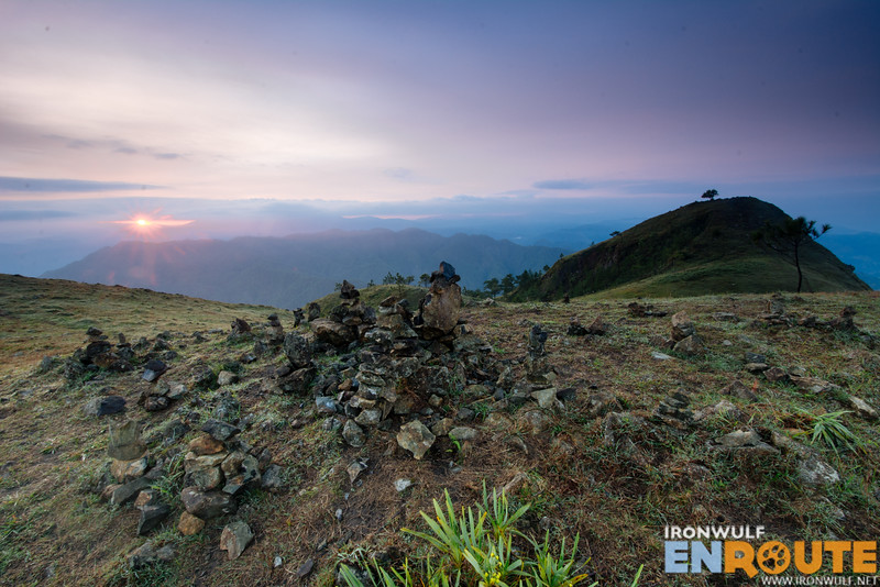
We reached Abanao Paoay by 4:30am. The darkness was enveloped in mist. Our headlamps could only illuminate up to 5 feet in front of us. We decided to wait there for the sunrise. The thick clouds quelled our expectations of a dramatic sunrise. Though the sliver opening through the clouds let us peak through the sun shyly hiding behind it. The light was subtle but soon we were able to see the landscape before us, a wide grassland with picturesque hills. The name aptly describes the place as Abanao means “vast” and Paoay means “grass”. There’s a wide ground for a camp site and also an area they call the rock balancing hill.


Gungal Rocks and Mt Ulap Summit on the next page…

Ferdz Decena is an award-winning travel photographer, writer and blogger. His works has found print in publications such as Singapore Airlines’s Silver Kris, Philippine Airlines’ Mabuhay, Cebu Pacific’s Smile and Seair InFlight. He has also lent his expertise to various organizations like the Oceana Philippines, Lopez Group Foundation, Save the Children and World Vision, contributing quality images for their marketing materials.